

Tuesday Ride Options
MAIN ROUTE: 61.9 miles, 5589 vertical ft, Tuesday, Main Ride
SHORTER ROUTE: 29.8 miles, 2099 vertical ft, Tuesday, Short Ride
LONGER ROUTE: 75.6 miles, 6406 vertical ft, Tuesday, Long Ride
(Download RideWithGPS route from link above)
If it is Tuesday, it must be the Queen Stage day.
Please wear your best smile and your Paso Gran Fundo cycling kit if you have one! We will gather on the Adelaide lawn for a group photo this morning promptly at 8:15AM. It’s a long day of riding, so we want to make it a quick photo so we can have wheels down at 8:30AM.
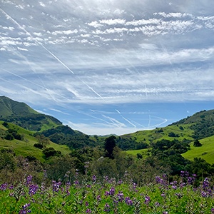
Today we will undertake some of the most challenging miles and climbs of the week while enjoying some of the area’s most thrilling terrain. There will be spectacular vistas of the coastline, a descent to the coast of the Pacific Ocean, a coffee stop in Cayucos, and a climb up Santa Rita Road including some dirt for those opting for the long route.
For those of you cycling the main route (62 miles and 5589 ft of elevation), there will be one SAG stop plus snacks in Cayucos. For those of you choosing to ride the long route (75.6 miles and 6406 ft of elevation), there will be two SAG stops on today’s ride, in addition to a coffee or snacks in Cayucos. The short route (30 miles and 2099 ft of elevation) does not have any SAG support today so carry plenty of snacks.
For most of us, this has become one of the quintessentially epic rides of Paso Gran FUNdo. What makes it so memorable are the considerable amounts of climbing, spectacular vistas heading to the coast, a coffee stop in Cayucos, beautiful country roads coming back east, and the climb up the dirt of Santa Rita.
For those of us doing the long and the short routes, we head out of Paso Robles and make our way over to Highway 46 (on either Vineyard Rd–long route or Willow Creek Rd–short route). The group cycling the short route (30 miles) will turn left at Hwy 46 (Green Valley Road) and return to Paso Robles. The group cycling the long route (75.6 miles) will take Vineyard to Jack Creek Road before turning right on Hwy 46 for the trip out to the Pacific Coast and the town of Cayucos. And for those choosing to ride the main route (62 miles and 5589 ft of elevation), I have routed you out of Paso Robles on Vine Street to Hwy 46 where you will turn right for the trip to the ocean and Cayucos. The first SAG stop for the main and long routes is at the summit at mile 17 for the main route and mile 27.7 for the long route. Shawn will park his SAG van off to the right near the summit. If it is a clear day, the summit on Highway 46 offers spectacular views south along the coast for at least 30 miles, including the Morro Bay Rock. From the summit, we’ll enjoy a 9-mile descent to Highway 1. Please ride carefully as the cross winds on the descent can be very tricky. We turn left on Hwy 1 and go south about 10 miles into the town of Cayucos, where we will stop for coffee and snacks at any number of places that the town offers.
From Cayucos, we climb up Old Creek Road past Whale Rock Reservoir on our left to the intersection of Santa Rita Road. Those of us doing the main route will stay on Old Creek Road and ride about 5+ more miles to Hwy 46 and the long descent back to Paso Robles. For those of us doing the long route, we turn right at Santa Rita Road and start our 6.5 mile climb up what is first pavement and then dirt to the summit where Shawn will be waiting for us with water and snacks to fuel our ride back to the Adelaide.
This is a long, hard day of riding, but it is also one of the most satisfying, rewarding and memorable. We hope you enjoy it. You will definitely have tales to share at dinner.
Here is a RidewithGPS overlay option of today’s routes – check the box for “Show all on map” to see all three routes together.
